

The Fascinating Truth About willis island
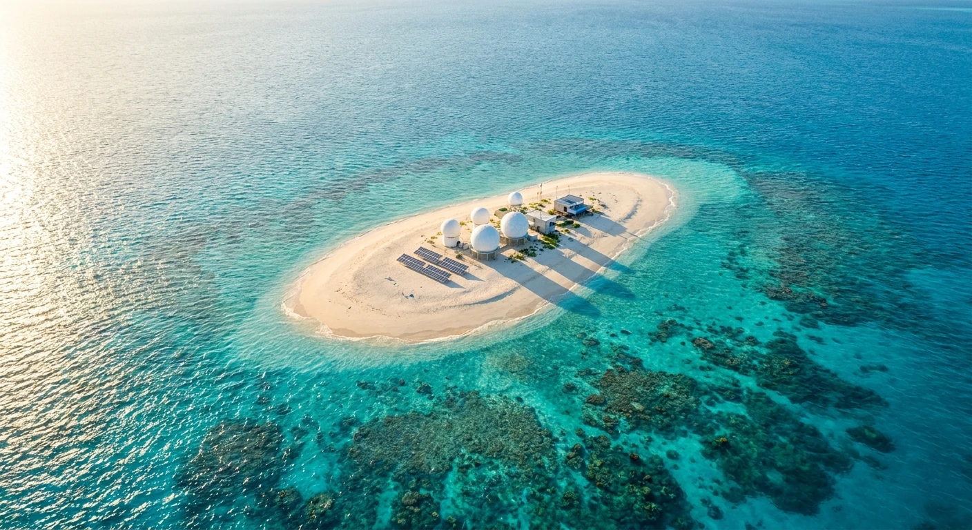
Hey there! If you are looking for the ultimate isolated getaway, or perhaps just tracking extreme weather patterns, you absolutely need to hear about willis island. You know how we always talk about escaping the grid and finding a place completely cut off from the noise of the city? Well, this tiny dot right out in the Coral Sea is literally the definition of off-grid living, but it comes with a highly crucial scientific twist. My buddy, who works in global meteorology, recently showed me some raw satellite feeds of this place, and I was completely blown away. It is just a tiny strip of sand, measuring about 500 meters long, yet it holds immense power over how an entire continent prepares for natural disasters.
The sheer isolation of the place makes you totally rethink what it means to be truly alone in the vast ocean. By the time you finish reading my thoughts on this unique spot, you will understand exactly why this microscopic territory is one of the most vital pieces of real estate in the Pacific. It is not just sand and a few tropical birds; it is a critical early warning system, a biological haven, and honestly, a testament to human resilience in the face of raging tropical cyclones. Imagine standing there, surrounded by nothing but deep blue water, knowing you are the first line of defense against massive storms. It is a heavy responsibility, but the crew out there handles it perfectly. Let me share with you exactly how this incredible place operates and why it continues to capture the imagination of weather buffs and cruise ship passengers alike.
Why This Micro-Island Matters So Much
Let me break it down for you. You might think it is just a random coral cay sitting pretty in the sunshine, but the weather station stationed on the sand provides massive benefits for mainland Australia and global climate tracking. Imagine sitting directly in the middle of what locals call “cyclone alley.” The value proposition here is incredibly simple yet vital: early detection of severe weather saves lives and prevents massive amounts of economic damage. For example, when severe tropical cyclones form out in the Coral Sea, the coastal weather radars simply cannot always catch the exact intensity early enough due to the curvature of the earth and distance. The personnel stationed here act as the ultimate frontline defense, sending back real-time data that satellites sometimes struggle to verify. Another great example is the biological conservation aspect. Because human access is so heavily restricted, the area has become a massive, undisturbed breeding ground for seabirds and marine life, entirely untouched by urban sprawl or pollution.
Here is a quick look at how it compares to other isolated weather outposts globally:
| Station Location | Primary Function | Isolation Level |
|---|---|---|
| Coral Sea (Australia) | Early Cyclone Warning & Ecology | Extreme (No regular public flights) |
| Macquarie Island | Sub-Antarctic Climate Data | Extreme (Ship access only) |
| Mauna Loa (Hawaii) | Atmospheric Carbon Monitoring | Moderate (Accessible by road) |
If you want to truly grasp how this ecosystem and station function side-by-side, you need to look at these critical operational factors that keep everything running smoothly:
- Constant Hazard Monitoring: The dedicated crew is constantly monitoring barometric pressure, wind speeds, and sea surface temperatures 24/7. They never take a day off from the data.
- Strict Quarantine Protocols: To protect the native bird population and delicate coral, bringing outside biological material, seeds, or unapproved food is strictly prohibited.
- Total Self-Sufficiency: They generate their own power using solar and diesel, desalinate their own drinking water, and manage waste without any municipal help whatsoever.
The Early Origins
So, how did anyone even think to put a permanent base out there? Back in the early 20th century, ships were constantly getting wrecked, and coastal towns were being battered by surprise cyclones. People were desperate for some sort of early warning system. In 1921, a guy named John King Davis basically spearheaded the movement to establish a meteorological station right on this sandy speck. They chose this specific spot because it was perfectly positioned in the direct path of where the most destructive storms historically formed. The initial setup was incredibly rugged. We are talking canvas tents, basic radio equipment, and absolutely zero luxury. The original crews had to endure brutal heat, relentless bird noise, and the constant threat of being completely swept away if a major storm hit before they could build stronger shelters.
Evolution of the Weather Station
As the decades rolled by, the infrastructure had to evolve drastically. You can only survive in a wooden shack for so long before a Category 5 storm teaches you a harsh lesson. Throughout the mid-to-late 1900s, the Australian Bureau of Meteorology poured resources into upgrading the facilities. They built reinforced concrete bunkers designed to withstand extreme wind velocities. Every time a major cyclone hit, they learned something new about structural engineering. A major turning point happened during Cyclone Yasi in 2011. That storm was an absolute monster. The eye passed directly over the station, causing significant damage and forcing an emergency evacuation of the staff. However, the data collected during that event was unprecedented. Following Yasi, the entire facility was rebuilt to be even stronger, incorporating state-of-the-art materials that can flex and hold during extreme weather events.
Modern State of the Outpost
Fast forward to the present day. Now that we are well into 2026, the station is an absolute marvel of modern engineering. The living quarters are surprisingly comfortable, equipped with high-speed satellite internet, which means the staff can actually FaceTime their families instead of relying on crackly radio feeds like the old days. The focus has also shifted heavily toward sustainability. They rely far more on advanced solar arrays and battery storage, drastically reducing the need for diesel fuel deliveries. Even though it remains incredibly isolated, the physical layout is designed to promote mental well-being for the small crew living there for months at a time. They have a gym setup, a massive digital library, and probably the best uninterrupted ocean views on the entire planet.
Atmospheric Monitoring Tech Explained
Okay, let us get a bit nerdy for a second. The gear they use out there is seriously impressive. The most critical daily task involves launching weather balloons, also known as radiosondes. These balloons are filled with hydrogen gas that the staff actually generate on-site. Once released, the balloon flies high into the stratosphere, beaming back precise data on temperature, humidity, and wind shear at different altitudes. This vertical slice of the atmosphere is exactly what supercomputers need to model where a cyclone is going to track. They also use advanced ultrasonic anemometers. Instead of those spinning cups you usually see for measuring wind, these devices use sound pulses to detect wind speed and direction, which means there are no moving parts that can easily break when the wind hits 200 kilometers per hour.
Avian Breeding Ecology
But it is not just about the weather gear; the biology happening around the radar domes is equally wild. The sandy cay is a critical habitat for several species that rely on its isolated beaches to survive. Because there are zero natural predators like cats or foxes, the birds have essentially taken over. Walking outside means navigating a maze of nests.
- Wedge-tailed Shearwaters: These birds literally dig burrows into the sand to lay their eggs, making the ground incredibly fragile to walk on.
- Masked Boobies: You will see these striking white and black birds nesting right out in the open, completely unafraid of the human observers.
- Green Sea Turtles: During the breeding season, massive turtles drag themselves up the beach at night to lay clutches of eggs in the warm sand, continuing a cycle that has lasted millions of years.
- Coral Reef Ecosystems: Just beneath the waves, the fringing reef supports vibrant marine life, acting as a natural breakwater that stops the sand from entirely washing away.
Day 1: Departing Cairns and Hitting the Coral Sea
Since you cannot just book a flight and rent an Airbnb out there, the best way to experience it is via a Coral Sea cruise. Day one is all about leaving the mainland behind. You depart from Cairns, grabbing your favorite drink, and watching the massive mountains of Far North Queensland slowly fade into the horizon. The excitement starts to build as the captain announces the trajectory straight out into the deep blue. You spend the evening getting your sea legs, mingling with fellow passengers, and maybe attending a guest lecture about the maritime history of the region.
Day 2: Navigating the Great Barrier Reef Margins
By the second day, you are cruising past the outer edges of the Great Barrier Reef. The water color shifts from a pale coastal green to an incredibly vibrant, dark indigo. This is a great day to grab some binoculars and hit the top deck. You might spot flying fish gliding alongside the hull or a pod of dolphins playing in the ship’s wake. The onboard naturalist usually gives a detailed talk about the delicate balance of the reef systems you are passing over, setting the stage for understanding why isolated cays are so vital to the ecosystem.
Day 3: Approaching the Willis Group
As you wake up on day three, the anticipation peaks. The ship is navigating through the Willis Group of islands. It is not just one island; there are a few tiny cays, but only one is inhabited. The captain slows the vessel down significantly. The radar shows a tiny blip ahead. The crew starts giving updates over the intercom, explaining the history of the meteorological station. You start to see vast flocks of seabirds circling the ship, a clear sign that land, however small, is very close.
Day 4: The Scenic Cruising Experience
This is the main event! The cruise ship does a slow, 360-degree scenic rotation around the island. Because the surrounding reef is shallow and delicate, the massive ship cannot dock, nor are passengers allowed to step foot on the sand to protect the quarantine zone. But you get incredibly close. From your balcony, you can clearly see the radar domes, the solar panels, and the Australian flag whipping in the wind. Sometimes, the station crew will come out on their balconies and wave large flags at the ship. It is a really cool, spontaneous moment of connection between thousands of vacationers and a handful of isolated scientists.
Day 5: Bird Watching and Deck Observations
After leaving the immediate vicinity of the cay, the birdlife remains incredibly active. Day five is perfect for amateur ornithologists. The ship is often trailed by frigatebirds and boobies that use the vessel’s updraft to glide effortlessly. The onboard photographers usually host workshops on how to capture fast-moving wildlife. You sit back, enjoy a coffee, and marvel at how these creatures survive hundreds of miles from the nearest substantial landmass.
Day 6: Understanding the Meteorological Equipment from Afar
Now that you have seen the station with your own eyes, the ship’s programming usually shifts to science. Guest speakers, sometimes retired meteorologists, break down exactly what the equipment you just saw is currently doing. They show real-time weather maps and explain how the data from that tiny patch of sand is feeding directly into global weather models. It gives you a profound appreciation for the silent work happening out there.
Day 7: The Journey Back to Mainland Australia
The final day at sea is all about reflection. As the ship makes its way back toward the coast, you pack your bags and swap photos with your new friends. You realize that out of all the places you could have visited, you saw something incredibly rare. You witnessed a fragile, vital outpost that most people do not even know exists. Arriving back in port feels different; you now have a unique understanding of how the mainland stays safe from the unpredictable fury of the Coral Sea.
Myths & Reality: Setting the Record Straight
Myth: You can easily book a hotel and spend a week lounging on the beach there.
Reality: It is strictly a government-run meteorological and conservation site. There are zero tourist facilities, no hotels, and public access to the shore is completely forbidden to protect the environment and equipment.
Myth: The staff working there are completely cut off from the rest of the world.
Reality: While physically isolated, they have access to high-speed satellite communications, internet, and daily contact with the mainland headquarters. They are remote, but absolutely not disconnected.
Myth: The landmass is sinking rapidly and will be completely submerged in a few months.
Reality: Like many low-lying coral cays, it faces long-term threats from rising sea levels and erosion, but it is constantly monitored. The reef structure provides stability, so it is not going to vanish overnight.
Myth: It never gets dangerously cold or harsh out there because it is tropical.
Reality: While it does not snow, the intense UV radiation, massive ocean swells, and hurricane-force winds during cyclone season make it an incredibly harsh environment that demands absolute respect.
Frequently Asked Questions
Who owns the territory?
It is an external territory of Australia, specifically managed under the Coral Sea Islands Act. The Bureau of Meteorology oversees the actual station facilities.
How many people live there?
Usually, there is a very small crew of just three or four highly trained observers and technicians who serve a six-month rotation.
How do they get their food?
Supplies are delivered by ship. They have large storage facilities, deep freezers, and a heavily planned inventory to ensure they do not run out of food during severe weather when ships cannot approach.
What happens if someone gets seriously sick?
In a life-threatening medical emergency, the Australian maritime authorities or defense force can coordinate a helicopter or fast boat evacuation, though the immense distance makes this very challenging.
Can cruise ships actually stop there?
No, they only perform scenic cruising. Ships sail slowly around the cay so passengers can view it, but no one leaves the ship to walk on the beach.
Do they have weapons for defense?
No, it is a purely civilian scientific outpost. There is no military presence or need for weaponry out in the middle of a marine park.
Are there any trees on the cay?
There is minimal vegetation, mostly low-lying coastal grasses and a few tough shrubs that can survive the highly saline environment and nesting birds.
Wrapping It All Up
So, there you have it! What seems like a totally insignificant dot on a map is actually a powerhouse of atmospheric science and ecological preservation. The sheer dedication of the people who spend months out there, launching balloons and tracking storms, is genuinely inspiring. The next time you hear a weather forecast warning about a tropical system moving toward the coast, you will know exactly where that crucial data came from. It is wild to think about, right? If you ever get the chance to take a cruise that sails past this legendary spot, do not hesitate for a second. It is a bucket-list experience for sure. If you loved learning about this remote wonder, share this guide with your travel buddies and start planning your next ocean adventure! Click the links around the site to read more about extreme off-grid locations!